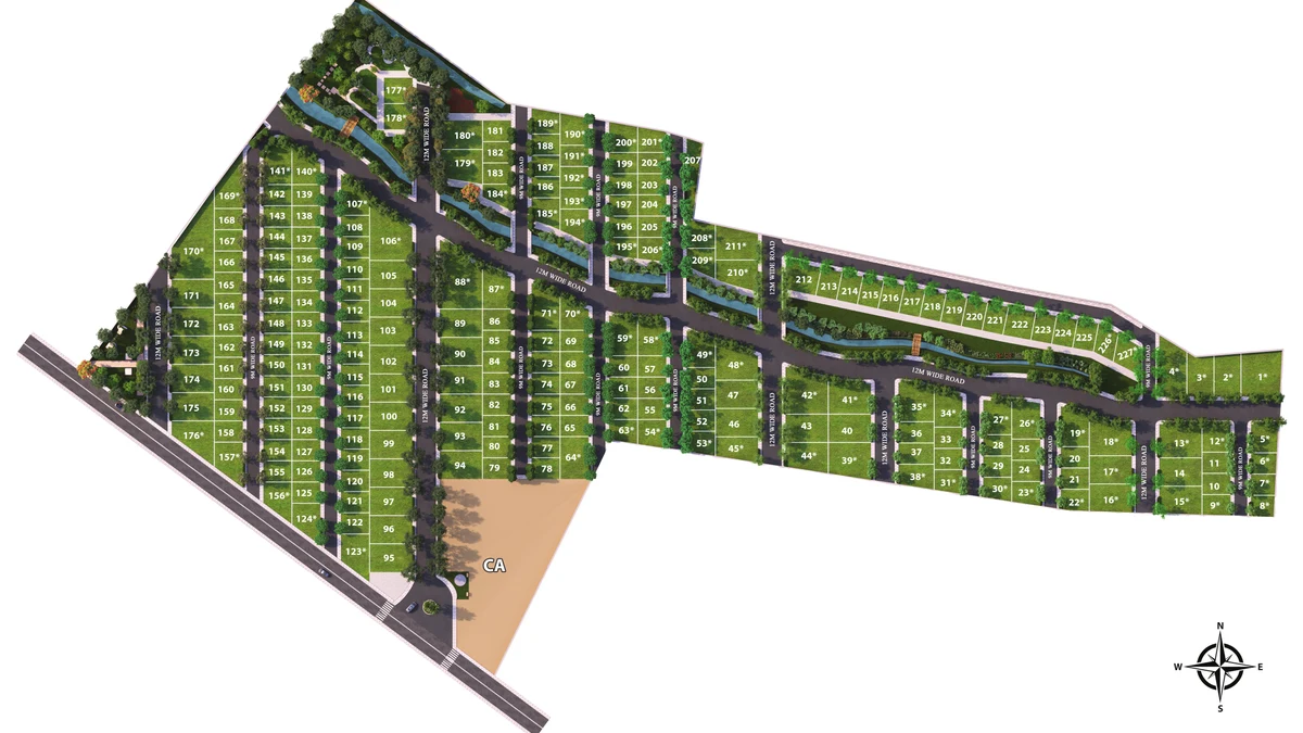
The master plan for Vaishnavi AT-One Life Phase 4 is unusually well documented, because Karnataka RERA holds the land-use table and the plot-by-plot schedule for the whole phase. That means the layout can be described from the filing rather than from a rendered drawing: 65,229 sq m of land, about 16.12 acres, divided into 34,058 sq m of saleable plots, 6,543 sq m of parks and open spaces across 8 numbers, 3,418 sq m across 2 civic-amenity sites and 21,210 sq m of roads.
Marketed as Yelahanka Extension; registered at Kamenahalli village, Kundana hobli, Devanahalli taluk, Bengaluru Rural 562110 - the district renamed Bengaluru North by Cabinet decision in July 2025. The layout was sanctioned by BIAAPA under BIAAPA/TP/LAO/2024-25 dated 19 December 2025 and registered with Karnataka RERA as PRM/KA/RERA/1250/303/PR/130526/008652, which appears on the register as VAISHNAVI AT-ONE LIFE IV - the same registration under its registry form. This page sets out how that land is used, what the road hierarchy actually delivers, where the amenities sit and where we could not establish it, how the work is sequenced, and what the layout means if you are choosing a plot.
The Filed Land Use
| Line | Area (sq m) | Share |
|---|---|---|
| Saleable plot area, 227 plots | 34,058 | 52.2% |
| Parks and open spaces, 8 numbers | 6,543 | 10.0% |
| Civic-amenity sites, 2 numbers | 3,418 | 5.2% |
| Roads | 21,210 | 32.5% |
| Total open area | 31,171 | 47.8% |
| Total land, Phase 4 | 65,229 | 100% |
Phase 4 is a filed 65,229 sq m - about 16.12 acres - of which 47.8% is parks, civic-amenity sites and roads. The acreage is our own conversion of the filed square metres at 4,046.856 sq m to the acre; the filed metric figure is the primary one and we show it alongside.
What that 47.8% actually contains
This is the single most useful thing on the page, and it is a scope point rather than a criticism.
Roads are the largest single component of the open area. At 21,210 sq m they are 32.5% of the whole site - nearly a third of the land - and they account for more of the 47.8% than the parks and the civic-amenity sites put together. Parks and open spaces are 10.0% of the land; civic-amenity sites are another 5.2%.
So a reader who sees "close to half the layout is open" and pictures parkland is picturing the wrong thing. Close to half the layout is not built on as plots, and most of that is the road network - which in a plotted development is not wasted land, because those roads are what make 227 individually sellable, individually buildable sites possible in the first place. But it is roads.
The developer markets "over 50% landscaped, green and open spaces" and "14 thematic parks". The filing for this phase records 47.8% and 8 parks. Where the two disagree, we publish the filing.
The eight parks and open spaces total 6,543 sq m, which by our own division averages a little over 800 sq m each. That is a pattern of distributed pocket greens rather than one large central park - though the filing records the count and the total area, not the individual sizes, so one of the eight could be materially larger than the rest.
Plots 1 to 227
| Type | Filed metric dimension | Nominal size | Plots | Filed area (sq m) |
|---|---|---|---|---|
| 30 ft x 40 ft | 9.14 m x 12.19 m | 1,200 sq ft | 123 | 13,704 |
| 40 ft x 60 ft | 12.19 m x 18.29 m | 2,400 sq ft | 27 | 6,020 |
| 30 ft x 50 ft | 9.14 m x 15.24 m | 1,500 sq ft | 2 | 278 |
| Odd-shaped sites | various | 1,035 to 5,409 sq ft | 75 | 14,056 |
| Total | 227 | 34,058 |
Plot numbering runs 1 to 227 with no gaps. The filed schedule lists every plot individually, with its area and its four boundaries - which is why the counts here are exact rather than approximate, and why the two Agreements for Sale executed so far can be identified by plot number.
Three characteristics of the layout follow from that table.
It is a 30 x 40 layout. 123 of 227 plots, 54% of the sites, are 30 x 40s occupying 13,704 sq m. Whatever else is in the mix, this is the product the layout is built around.
The 30 x 50 does not really exist here. Two plots, 278 sq m between them. If a 1,500 sq ft site is your requirement, plan around a 30 x 40 or a 40 x 60.
The odd-shaped sites are where the variety lives. 75 plots - a third of the layout - are irregular, and together they hold 14,056 sq m, more land than all 123 of the 30 x 40s combined. They are also where the size range comes from: the publishable band is 1,035 to 5,409 sq ft, and that band is set by these plots at both ends. In a layout, irregular plots are usually the ones that fall against a curve in the road, a corner, a boundary or a park edge. Which of those applies to any given plot number is recorded in the filed boundary schedule, and it is the single most useful document to ask for before you choose.
The Road Hierarchy
| Element | Width | Source |
|---|---|---|
| Internal roads | 9 m and 12 m | Filed. The plot schedules reference only these two widths |
| Entrance avenue | 18 m grand entrance | The developer's sales presenter |
The filing supports two internal road widths and nothing else. A claim of "9 m to 18 m wide internal roads" circulates for this project; the 18 m is the entrance avenue, not an internal street, and the two should not be run together into a range.
What those widths deliver, in the terms buyers actually use: the filed plot schedule equates 9.14 m with 30 ft, 12.19 m with 40 ft and 18.29 m with 60 ft. On those same conversions, a 9 m road is a shade under a 30 ft road, a 12 m road a shade under 40 ft, and the 18 m entrance a shade under 60 ft.
That is a real hierarchy rather than a nominal one. A 9 m carriageway takes two-way movement with kerbside parking on one side and still leaves room for a footpath - adequate for a residential street serving 30 x 40 sites, and comfortably better than the 6 m and 7.5 m roads common in older unplanned layouts in this belt. A 12 m road is a spine: two-way movement, parking both sides, footpaths both sides, and enough width for the drainage and utility runs to sit under the verge rather than under the carriageway. And a 12 m frontage genuinely changes how a house feels from the street, which is why wider-road plots normally attract a preferential location charge.
The road network is also where a large share of the money goes. The filed quarterly update as at 16 July 2026 puts roads, footpaths, drainage and electrical poles at 40% complete, started 2 March 2026, against plot formation at 70%. Roads lag plot formation, which is the usual sequence and worth tracking on the next quarterly filing rather than taking on trust.
Where the Amenities Sit
Here is what the filing establishes, and here is what it does not.
Established. Eight parks and open spaces totalling 6,543 sq m. Two civic-amenity sites totalling 3,418 sq m. Both counts and both areas come from the Karnataka RERA land-use table.
Not established. Where in the layout any of them falls. The filing records counts and areas, not positions, and we have not been able to establish from it or from the developer's collateral which numbered plot sits where, which plots face a park, or whether the clubhouse the developer describes will be built on one of the two civic-amenity sites. We are not going to guess, because a park-facing plot is exactly the kind of thing a buyer pays a premium for, and a guess here would cost someone money.
The amenity programme itself is the developer's, and this is the point at which to say so plainly: the 32,750 sq ft courtyard-themed G+2 clubhouse, the 2-acre central activity space, the tree-lined avenues, the water features and the entrance portal are all descriptions from the developer's own sales presenter and websites, of things not yet built. The 2-acre central activity space in particular is estate-level in origin and is not a Phase 4 filed figure. The quarterly filing shows this phase's construction spend concentrated in plot formation and roads, with plantation recorded at 0% and scheduled to start from 17 August 2026 - so the landscape, at the date of that filing, had not begun.
That said, a 32,750 sq ft clubhouse serving 227 plots is a high amenity provision for a layout this size, and the three delivered phases give the intention more weight than a first-time developer's brochure would carry.
The utilities picture on the master plan is: borewell as the filed water source, BESCOM for power with the transformer and substation recorded at 0% and scheduled from 1 August 2026, and no municipal sewer network - on-site treatment is required under the KSPCB consent and the BIAAPA layout conditions. No treatment-plant capacity has been filed, because no environmental clearance exists for a layout of this size and none is required; any KLD figure quoted for this project has been invented. The developer describes "pre-engineered smart plots with underground electric, water and sanitary lines", which is its wording and worth confirming against the sanctioned layout plan.
Phasing and Sequence
Phase 4 is itself the fourth phase of the estate, and it is registered as a single project with one filed completion date of 18 December 2027. No internal sub-phasing is declared on the filing, and no extension of time has been applied for.
What the filing does declare is a work sequence, and that is the phasing a buyer can actually track:
| Work | Started or scheduled | Status at 16 July 2026 |
|---|---|---|
| Formation of plots | Started 16 February 2026 | 70% |
| Roads, footpaths, drainage, electrical poles | Started 2 March 2026 | 40% |
| Power supply, transformer and substation | Scheduled from 1 August 2026 | 0% |
| Plantation | Scheduled from 17 August 2026 | 0% |
| Other miscellaneous work | 5% |
The promoter's July 2026 quarterly filing reports 65% completion overall, with plot formation at 70% and internal roads at 40%; power supply and plantation had not started, and ₹9.4 crore of an estimated ₹30.7 crore construction budget had been spent. The 65% is the promoter's own single-line self-assessment; the components and the spend both sit below it, and both come from the same document.
For the estate as a whole, Phase 4 is the last of four registered phases: 227 plots on about 16.12 acres, the fourth phase of Vaishnavi's roughly 66-acre AT-One Life estate, which runs to about 900 plots in total across the four registrations. Phases I to III are on Bettanahalli land and are delivered; Phase 4 is on Kamenahalli land close to the delivered Bettanahalli phases, and the mapped road route between them runs 4.4 km. It is about 1 km in a straight line, but no direct road north from the earlier layout into Kamenahalli is mapped, so we do not describe Phase 4 as adjacent to them. If you visit, this is a specific thing to check on the ground and to ask the site team about, because a through-connection would change the practical relationship between the two considerably.
Orientation and the Site's Setting
The promoter's filed coordinate for this registration is 13.2141 N, 77.5973 E. It is a primary-source figure and it is what a diligence check reconciles against, but it falls inside the mapped footprint of the delivered Phases I to III, so it most likely records the estate or the site office rather than the Kamenahalli parcel itself - the Kamenahalli village node lies about 1 km north. Phase I's own filed coordinate sits about 250 m from Phase IV's, which supports that reading. The actual parcel polygon is not established: Karnataka's KGIS and Bhu-naksha cadastral services returned 404 on every endpoint we tried, so only the village is confirmed. Treat any map of this site, including ours, as approximate.
On bearings, the developer's own site map is captioned "map not to scale", and its directions do check out against real coordinates. Dyavarahalli Main Road runs immediately north of the site. Bellary Road - NH-44 - is to the east, and the parcel sits west of the highway, not on its approach. MS Engineering College is east; Windflower Prakruthi to the south-east; Embassy International Riding School and Stonehill International School to the south-south-west; Doddaballapur Road far to the west.
Those bearings are consistent with the filed address in Kundana hobli, not with the Yelahanka Extension marketing line. The map is describing where the land is; the cover of the same document is describing where the buyer is expected to think it is.
What This Layout Means If You Are Choosing a Plot
Premium positions. In a plotted layout the positions that normally carry a preferential location charge are corner plots, park-facing plots, plots on the wider road and plots near the entrance. All four categories exist here in principle - there are two road widths, eight parks and an entrance avenue. Vaishnavi's PLC structure for this project is not established. The developer publishes no price of any kind, so it publishes no PLC schedule either, and any PLC figure quoted to you should be asked for in writing.
The two documents to ask for. The sanctioned layout plan, BIAAPA/TP/LAO/2024-25 dated 19 December 2025, and the filed plot schedule that lists your plot number with its area and its four boundaries. Between them they answer where your plot sits, what it abuts, how wide the road in front of it is and what is opposite. Read them before you read anything rendered.
Setbacks and what you can build. The Karnataka RERA record does not publish a building-setback or coverage schedule for individual plots. What governs a house on a plot here is the sanctioned layout's own conditions and the byelaws applying to a BIAAPA-sanctioned layout on gram-panchayat khata - not a figure from a brochure and not the rules that apply inside Bengaluru's municipal limits. Ask for the setback and coverage conditions attached to the sanctioned layout plan, in writing, before you finalise a plot for a specific house design. We could not establish them and we are not going to estimate them.
Two scope errors to avoid. Phase 4 is 227 plots on about 16.12 acres. The 66-plus acres and 898 plots the developer publishes describe the four-phase estate; the four filings sum to 66.36 acres and 899 plots. And the open-space figure for this phase is 47.8% as filed, not the "over 50%" that circulates.
Enquire About the Vaishnavi AT-One Life Phase 4 Masterplan
The filing records how many parks there are and how large they are, but not where they sit. Ask for the sanctioned layout plan and your plot's own line from the filed schedule before you choose a plot number.
Talk to a Sales ConsultantFrequently Asked Questions
Master Plan - Vaishnavi AT-One Life Phase 4 FAQs
Gram Panchayat khata, on all seven survey numbers, issued through e-Swathu. There is no BBMP or Greater Bengaluru khata here because the land is not inside any municipal corporation, city municipal council or town panchayat. The layout was sanctioned by BIAAPA, the Bangalore International Airport Area Planning Authority, under BIAAPA/TP/LAO/2024-25 dated 19 December 2025 - not by BDA, BMRDA or BBMP. Every one of the seven survey numbers carries a conversion order to residential use from the Deputy Commissioner, Bangalore Rural. That BIAAPA-plus-panchayat-khata chain is the normal pattern for this jurisdiction.
There is no environmental clearance, and none is required. A plotted layout of this size sits below the EIA Schedule 8(b) threshold. The absence of an EC here is not a gap and is not an existence doubt - the signed K-RERA certificate settles that the project exists and is registered. One practical consequence: because no EC exists, there is no filed sewage-treatment capacity figure either, so nobody can quote you a KLD number for this project.
There is no municipal sewer network at this location. On-site treatment is required under the KSPCB consent and the BIAAPA layout conditions. Because no environmental clearance exists, there is no filed treatment-capacity figure, and we will not publish an invented one. Ask for the sanctioned sewage arrangement named in the BIAAPA layout approval, and ask who operates and pays for it after handover.
47.8% of the land, as filed. The Karnataka RERA land-use table for Phase 4 records 34,058 sq m of saleable plots (52.2%) against 31,171 sq m of open area (47.8%), made up of 8 parks and open spaces totalling 6,543 sq m, two civic-amenity sites totalling 3,418 sq m, and 21,210 sq m of roads. The developer markets "over 50% landscaped, green and open spaces" and "14 thematic parks"; the filing for this phase says 47.8% and 8 parks. Internal roads are 9 m and 12 m wide, with an 18 m entrance avenue.
The developer describes "pre-engineered smart plots with underground electric, water and sanitary lines" - that is its own wording and its own claim. What the filing establishes is that the water source is borewell, the electricity distributor is BESCOM with its NOC recorded as approved, and the internal roads are 9 m and 12 m wide. As at the July 2026 quarterly filing, power supply work - transformer and substation - had not started and was scheduled to begin from 1 August 2026.