Vaishnavi AT-One Life Phase 4 is a 227-plot layout in Kamenahalli village, Kundana hobli, Devanahalli taluk, west of the Bengaluru airport highway. The developer sells the address as Yelahanka Extension, North Bengaluru. The signed Karnataka RERA certificate says something more precise, and this page publishes the certificate's version alongside the marketing one, because the difference is material to what a buyer is actually buying.
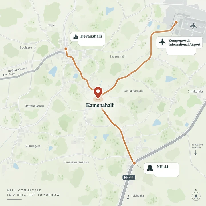
The developer markets this address as Yelahanka Extension, North Bengaluru. The signed Karnataka RERA registration places the land at Sy Nos 65/1, 65/2, 65/3, 65/4, 66, 67/2, 67/3, 68/3 and 68/4 of Kamenahalli village, Kundana hobli, Devanahalli taluk, Bengaluru Rural district, PIN 562110 - about 9.9 km of village road west of NH-44 and 19.7 km by road from Yelahanka New Town, in a different taluk and a different district from Yelahanka.
The Filed Address, Printed Verbatim
This is the address string as it appears on the digitally signed K-RERA certificate for registration PRM/KA/RERA/1250/303/PR/130526/008652, approved 13 May 2026 in the registry name VAISHNAVI AT-ONE LIFE IV.
Sy Nos 65/1, 65/2, 65/3, 65/4, 66, 67/2, 67/3, 68/3, 68/4 of Kamenahalli Village, Kundana Hobli, Devanahalli Taluk, Devanahalli, Bengaluru Rural, Karnataka - 562110
Two notes a diligence reader will want. First, the certificate itself spells the village name with three L's. That is a typo on the certificate, and a literal search on the certificate's spelling returns nothing at all; the village is Kamenahalli. Second, the K-RERA land table uses slightly different sub-numbering for the same parcel - it reads 65, 66/1, 66/2, 67/2, 67/3, 68/3, 68/4. Same land, different granularity. The certificate's string is the signed one, so it is the one published here.
Administrative Identity
| Field | Value |
|---|---|
| Revenue village | Kamenahalli |
| Hobli | Kundana, one of four hoblis in Devanahalli taluk |
| Taluk | Devanahalli |
| District | Bengaluru Rural, renamed Bengaluru North by Cabinet decision in July 2025 |
| PIN | 562110 |
| Planning authority | BIAAPA - Bangalore International Airport Area Planning Authority |
| Layout sanction | BIAAPA/TP/LAO/2024-25, dated 19 December 2025 |
| Khata | Gram Panchayat khata on all seven survey numbers, issued through e-Swathu |
| Urban local body | None. No municipal corporation, city municipal council or town panchayat governs this parcel |
| Land conversion | Deputy Commissioner, Bangalore Rural, on every survey number, to residential use |
| Coordinates as filed | 13.2141 N, 77.5973 E |
Not BMRDA, not BDA, not BBMP. BIAAPA is the planning authority for the airport belt and it sanctioned all four AT-One Life layouts. The khata is a Gram Panchayat khata, not a BBMP A-khata, and a buyer should price in what that means for future building approvals and for any later transition into a municipal body.
Two things are honestly not established. The specific gram panchayat that serves survey numbers 65 to 68 could not be confirmed; Kundana is the hobli headquarters and routes at 6.9 km. And the parcel polygon itself is not established - Karnataka's KGIS and Bhu-naksha cadastral services returned errors on every endpoint, so only the village is confirmed. Any map on this site is approximate.
Note also that Phases I, II and III of this estate are in Bettanahalli, a different revenue village in the same hobli. Portals routinely index the whole estate under Bettanahalli. Phase 4 is Kamenahalli, and the certificate says so.
How the Distances on This Page Were Produced
Distances are road-routed on OpenStreetMap data and cross-checked on a second routing engine, and carry a band of about 1.5 km. Free-flow minutes come from the routing engine. Peak-hour minutes are a modelled estimate, not a measured drive time - they apply 25 km/h to the rural and highway leg and the TomTom Bengaluru congestion benchmark to any part of the trip that ends inside the built-up city.
Every kilometre below is a road route, not a straight line. The routing origin sits about 1.0 km from the coordinate the promoter filed with K-RERA, which is well inside the band the table already carries. Where the two routing engines disagreed by more than half a kilometre it is stated in the row.
The Connectivity Fact Nobody Else States
Every trip out of this parcel, in every direction, begins with about 8 to 10 km of unnamed village road.
The routed trace from the site to the airport runs 9.9 km entirely on unnamed rural roads - east, then south along the Bettahalasur corridor, then east again - before it touches a road that carries a name at all. Only then does it reach Ballari Road. The site's southbound spine acquires the name Sir MVIT College Road where it is signed.
No developer collateral mentions this. It is the single most important thing to understand about the location, and its practical consequences are ordinary and real: construction traffic on a single-lane surface, no street lighting for much of the run, and a genuine monsoon-season surface risk. Drive it yourself, at night, before you decide.
Roads, Airport and the City
| Destination | Routed km | Free-flow | Peak estimate |
|---|---|---|---|
| Kempegowda International Airport, Terminal 2 access road | 17.4 | ~24 min | ~40 min |
| Nearest NH-44 / Ballari Road access | 9.9 | ~16 min | ~25 min |
| IVC Road, nearest mapped segment | 7.1 | ~13 min | ~15 min |
| STRR / NH-648, nearest point | 11.7 | ~15 min | ~30 min |
| STRR / NH-648 at Kundana junction | 12.2 | ~19 min | ~30 min |
| NH-44 Devanahalli / Sadahalli toll plaza | 14.8 | ~23 min | ~35 min |
| Devanahalli town | 15.3 | ~23 min | ~35 min |
| Doddaballapura town | 19.1 | ~23 min | ~45 min |
| Yelahanka New Town | 19.7 | ~26 min | ~45 min |
| Hebbal flyover | 29.0 | ~35 min | ~80 min |
| Bengaluru CBD, Vidhana Soudha | 33.2 | ~40 min | ~95 min |
Where the Marketing and the Routing Disagree
| Developer's claim | Where it appears | What the routing found |
|---|---|---|
| A "Closest Metro Station" distance in single-digit kilometres | Corporate project page | Unrouted, and to a station that has not opened. The nearest station of any line is Doddajala at 10.1 km by road, under construction. The nearest operational station is 32 to 38 km away |
| "20 min from KIAL" | Campaign site | 17.4 km, about 24 min free-flow and about 40 min at peak |
| "25 min from Hebbal Flyover" | Campaign site | 29.0 km, about 35 min free-flow and about 80 min at peak. The developer's figure is a free-flow number presented as a drive time |
| "Located Before the Airport Toll" | Campaign site | The Devanahalli / Sadahalli toll plaza routes at 14.8 km, and the parcel sits west of NH-44 rather than on the highway approach |
| "Signal-Free Access to KIAL" | Corporate page | The first 9.9 km of any route out of the parcel is unnamed village road |
| A single-digit distance to the STRR | Marketing collateral | A straight-line figure. The routed distance is 11.7 km, because the local road grid does not run straight north |
| "Yelahanka Extension, North Bengaluru" | Cover, footer, both developer sites | Yelahanka New Town is 19.7 km by road, in a different taluk and a different district. Forcing a route through the Bettahalasur corridor comes out longer still, at 20.3 km, so there is no shorter back road |
The developer also understates one thing. Its collateral barely mentions Prestige Tech Cloud Park at Doddajala, which at 10.4 km is the closest large office address to the parcel.
One more correction, because it appears on the developer's own location map. That map places a cricket academy to the north-west of the site, on the STRR, and presents it as a facility still to come. The BCCI Centre of Excellence, the facility that replaced the National Cricket Academy, is at Singahalli, 21.8 km east-south-east, on the far side of the airport, and it was inaugurated in September 2024. Wrong quadrant, and wrong tense.
Metro - Name the Station, the Status and the Route
There is no operational metro within an hour of this parcel at peak. That is the plain position, and it will stay true for some years.
| Station | Line and status | Routed km | Free-flow | Peak estimate |
|---|---|---|---|---|
| Doddajala | Blue Line, under construction | 10.1 | ~17 min | ~25 min |
| Bagalur Cross | Blue Line, under construction | 16.4 | ~21 min | ~40 min |
| KIAL Terminals | Blue Line, under construction | 18.1 | ~26 min | ~45 min |
| Yelahanka | Blue Line, under construction | 18.6 | ~24 min | ~45 min |
| Nagawara | Pink Line, under construction | 28.2 | ~33 min | ~75 min |
| Nagasandra | Green Line, operational | 32 to 38 | ~41 min | ~90 min |
| Madavara / BIEC | Green Line, operational | 35.1 | ~45 min | ~100 min |
Doddajala is the nearest station of any line and it is a depot site as well. It is genuinely under construction - piers are up - so "proposed" would understate it and "1.5 km" is simply wrong. On the Blue Line's own published schedule, Phase 2A trial runs start from October 2026, commercial operation has slipped into 2027, the Hebbal to airport section is targeted for September 2027, and in August 2026 the full corridor was pushed to March 2028.
The Nagasandra row is the one figure on this page that the two routing engines could not agree on - 32.2 km on one, 37.5 km on the other. It is published as a band for that reason. Every other headline number here is stable to within 0.2 km across both engines.
The Pink Line's underground stretch to Nagawara is targeted for December 2026, and the Bannerghatta Road section missed its 15 August 2026 launch date. When Nagawara opens it becomes the nearest operational station, at 28.2 km.
Employment
| Destination | Routed km | Free-flow | Peak estimate |
|---|---|---|---|
| Prestige Tech Cloud Park, Doddajala | 10.4 | ~19 min | ~25 min |
| Bengaluru Airport City / Devanahalli Business Park | 14.9 | ~22 min | ~35 min |
| Hinduja Ecopolis SEZ, Kogilu | 15.3 | ~21 min | ~35 min |
| AstraZeneca India R&D, Bellary Road | 15.7 | ~20 min | ~40 min |
| KIADB Aerospace Park | 23.4 | ~33 min | ~60 min |
| Bhartiya Centre of Information Technology | 23.4 | ~30 min | ~60 min |
| Kirloskar Business Park, Hebbal | 24.6 | ~31 min | ~65 min |
| Manyata Tech Park | 28.4 | ~35 min | ~80 min |
| KIADB Hi-Tech Defence and Aerospace Park, Chennarayapatna | 30.0 | ~31 min | ~85 min |
Prestige Tech Cloud Park at 10.4 km is the only large office address inside a reasonable daily commute. Manyata, at 28.4 km and about 80 minutes at peak, is not a daily commute from here and should not be treated as one.
No acreage or tenant count for the KIADB Aerospace Park appears on this site. Every such figure that circulates for it traces back to broker microsites rather than to KIADB or to any filing, so none of them is established and none is published here.
Schools and Colleges
| Destination | Routed km | Free-flow | Peak estimate |
|---|---|---|---|
| Morarji Desai Residential School, Kundana | 6.3 | ~10 min | ~15 min |
| Stonehill International School, Tarahunise | 8.4 | ~13 min | ~20 min |
| MS Engineering College, Navarathna Agrahara | 8.5 | ~16 min | ~20 min |
| Sir M. Visvesvaraya Institute of Technology, Hunasamaranahalli | 11.0 | ~15 min | ~25 min |
| Vidyashilp Academy, Jakkur / Yelahanka | 12.7 | ~20 min | ~30 min |
| Nitte Meenakshi Institute of Technology, Yelahanka | 14.0 | ~22 min | ~35 min |
| Ryan International School, Yelahanka | 15.0 | ~22 min | ~35 min |
| BMS Institute of Technology and Management, Avalahalli | 15.6 | ~22 min | ~35 min |
| REVA University, Kattigenahalli | 19.2 | ~24 min | ~45 min |
| Canadian International School, Yelahanka | 19.7 | ~29 min | ~45 min |
| Delhi Public School Bangalore North, Sathanur | 20.3 | ~27 min | ~50 min |
| University of Agricultural Sciences, GKVK | 23.8 | ~38 min | ~60 min |
Stonehill at 8.4 km is the genuinely close international school. Everything from Vidyashilp outward is a 12 to 20 km school run, twice a day, beginning on that village road.
The developer's collateral lists roughly seventeen further school, hospital and leisure names with no distances beside them - Chrysalis High, Millennium World School, Orchids International, People Tree Hospital and others. None of them could be resolved to a single unambiguous coordinate, so no distance for any of them appears on this site. Where a name is ambiguous across several Bengaluru campuses, a published distance would be a guess.
Healthcare - The Sharpest Drawback on This Parcel
| Destination | Routed km | Free-flow | Peak estimate |
|---|---|---|---|
| Kundana PHC, government primary health centre | 5.9 | ~10 min | ~15 min |
| Akash Institute of Medical Sciences and Hospital, Devanahalli | 15.6 | ~25 min | ~35 min |
| Cytecare Cancer Hospital, Venkatala Yelahanka | 18.4 | ~24 min | ~45 min |
| Manipal Hospital Yelahanka | 18.9 | ~25 min | ~45 min |
| Bangalore Baptist Hospital, Hebbal | 26.2 | ~31 min | ~70 min |
| Aster CMI Hospital, Hebbal | 26.6 | ~31 min | ~70 min |
Read that table as a night-time emergency, because that is when it matters. The nearest government facility is a primary health centre at 5.9 km, and a PHC is not a 24x7 emergency room. The nearest multi-speciality options are 15.6 to 18.9 km. A serious emergency realistically means Aster CMI or Baptist at Hebbal, 26 to 27 km away, on village roads, at night, with no ambulance staging anywhere nearby. A household with an elderly parent or a medically fragile member should weigh this before anything else on this page.
Retail and Everyday Life
| Destination | Routed km | Free-flow | Peak estimate |
|---|---|---|---|
| Windflower Prakruthi Resort and Spa | 5.4 | ~10 min | ~15 min |
| Padukone-Dravid Centre for Sports Excellence | 8.1 | ~12 min | ~20 min |
| Club Cabana, Shettigere | 8.4 | ~15 min | ~20 min |
| Embassy International Riding School | 8.6 | ~14 min | ~20 min |
| Decathlon, Chikkajala | 10.7 | ~17 min | ~25 min |
| Nearest mapped fuel station | 11.3 | ~18 min | ~25 min |
| Angsana Oasis Spa and Resort | 14.7 | ~19 min | ~35 min |
| The Galleria Mall, Yelahanka | 19.9 | ~25 min | ~50 min |
| BCCI Centre of Excellence, Singahalli | 21.8 | ~29 min | ~55 min |
| Bhartiya Mall of Bengaluru, Thanisandra | 23.8 | ~30 min | ~60 min |
| Phoenix Mall of Asia, Byatarayanapura | 23.9 | ~31 min | ~60 min |
| Esteem Mall, Hebbal | 24.7 | ~30 min | ~65 min |
The important line in that table is the fuel station at 11.3 km. Within roughly 5 km of the site there is no mapped pharmacy, no clinic, no hospital, no supermarket and no convenience store. A structured query over the surrounding area returned one fuel station at 11.3 km, one school inside a gated township at 5.2 km, and the Kundana residential school at 6.3 km. Absence from the map data is not absolute proof of absence on the ground, but the pattern is unambiguous, and a buyer should plan on driving for everything for the first several years.
What Is Actually on the Ground Today
This is a farming pocket, not a suburb. An extract of roughly 2.2 km by 2.6 km around the pin returns farmland, orchards, a farmyard, eleven irrigation tanks, three village nodes, one named road, and three platted residential polygons. That is the entire built environment.
The nearest neighbouring layout is Green Field Garden 4, immediately east, at 0.8 km by road, developed by the Telecom Employees Co-operative Housing Society. Beyond it, Orchid Nirvana at 3.5 km, Rain Forest and Eden 144 at 3.8 km, Adarsh Savana at 4.3 km and Embassy Springs at 5.1 km.
The developer's own delivered phases are close but not connected in the way the marketing implies. Phase 4 is on Kamenahalli land close to the delivered Bettanahalli phases; the mapped road route between them runs 4.4 km. Straight-line the two are about a kilometre apart, but no direct road north from the earlier layout into Kamenahalli is mapped, so the route loops east, south, then back west. Either there genuinely is no through-connection, which is worth knowing, or the internal link is unmapped. Ask on site.
Water - The Material Risk
There is no piped municipal water here. The parcel sits outside BWSSB's service area entirely, and BWSSB has no service area in Devanahalli taluk. The water source recorded on the K-RERA filing is borewell. Supply in practice means groundwater, gram-panchayat borewells and tankers.
The groundwater series for this taluk is the number to sit with:
| Measure | Value |
|---|---|
| Devanahalli taluk water table, March 2015 | 32.2 metres below ground level |
| Devanahalli taluk water table, March 2024 | 73.74 metres below ground level |
| Groundwater classification | Officially over-exploited, meaning extraction above 100% of annual recharge |
| Rural Bengaluru gram-panchayat drinking-water borewell depth, 2001 to 2011 | 183 metres |
| Rural Bengaluru gram-panchayat drinking-water borewell depth, 2011 to 2021 | 321 metres |
That is the sharpest fall of any zone near Bengaluru, and it is the context in which a 227-plot layout will run on borewells plus on-site treatment. There is no municipal sewer network either; on-site treatment is required under the KSPCB consent and the BIAAPA layout conditions. No treatment-plant capacity figure is published on the filing, because no environmental clearance exists for a layout of this size and none is required, so there is no filed capacity to quote. We will not invent one.
Yettinahole is sometimes offered as the answer to all of this. No delivery date for these villages is established, and it should not be treated as a solved water source for this project.
What to do about it: ask the developer, in writing, for the sanctioned water source named in the BIAAPA layout approval, and ask what the borewell yield and depth on site actually are.
Infrastructure Pipeline, With a Status for Each Item
| Project | Status as at 31 August 2026 | What it means here |
|---|---|---|
| Namma Metro Blue Line | Under construction, not operational. Trial runs from October 2026, commercial operation slipped into 2027, Hebbal to airport targeted September 2027, full corridor pushed to March 2028 | Nearest station Doddajala, 10.1 km routed |
| Nearest operational metro | Operational | Nagasandra on the Green Line, 32 to 38 km. No operational metro within an hour at peak |
| Pink Line to Nagawara | Under construction. Underground stretch targeted December 2026; the Bannerghatta Road section missed its 15 August 2026 launch | Nagawara routes at 28.2 km and becomes the nearest operational station when it opens |
| STRR / NH-648 | Operational. The 80 km Dobbaspet to Hoskote stretch opened on 11 March 2024; remaining sections targeted November 2026 | 11.7 km routed to the nearest point, 12.2 km to Kundana junction. This is the one item the developer understates |
| Bengaluru Business Corridor, formerly the Peripheral Ring Road | Land acquisition and tendering. Not under construction. Environmental clearance granted 27 April 2026, Package 1 bids opened 8 May 2026 | The alignment does not come near Kamenahalli. Its closest approach is the Bagalur area, 15 to 20 km south |
| Suburban rail, Corridor 1, KSR to Devanahalli | Zero ground construction. Yelahanka to Devanahalli stated for December 2026, KSR to Yelahanka for December 2027 | With no ground work under way, the 2026 date is not credible |
| KIADB Aerospace Park | Operational and expanding | 23.4 km routed. No acreage or tenant count is published here because none is established |
| Bengaluru Airport City | Under construction. 2 million sq ft of business park across 17.7 acres in four blocks, and a 775-room combination hotel due at the end of 2026 | 14.9 km routed |
| Prestige Tech Cloud Park, Doddajala | Built, with an extension under construction | 10.4 km routed, the closest large office address |
| KWIN City | Announced, land acquisition under way, no construction. Contested, with farmer protests in Doddaballapur | No distance is published, because no filed boundary exists |
| The Quad by BLR | Opened in 2019, currently under refurbishment | The developer's collateral presents it as a future attraction. It has been open for years |
| Foxconn | Operating and hiring. A 300-acre campus in the ITIR across Devanahalli and Doddaballapura taluks, a ₹20,000 crore investment, 30,000 people hired in eight months | The largest single driver of the corridor's land story |
Market Context for the Micro-Market
Two things a buyer holding for three to seven years should hold in view.
The corridor's measured record. ANAROCK's Devanahalli Micro Market Report of July 2024 put the Devanahalli average base selling price at ₹6,778 per sq ft in Q4 2023, with 46% appreciation between Q4 2016 and Q4 2023, and a price index that reached 146 against 133 for North Bengaluru as a whole on a 2016 base. The same report notes the product mix moving upmarket - 7% of supply between 2016 and 2023 was priced above ₹1.5 Cr, against 16% of 2023 supply alone. Knight Frank's India Real Estate H1 2026 named North Bengaluru the fastest-growing corridor in the city, with launches up 10% and sales up 11%, and put the Bengaluru average residential price at ₹9,354 per sq ft, up 9% year on year.
The supply position. The Devanahalli registration office 1250/303, the same office that registered this project, carries 303 registered projects. Of those, 68 were registered in 2025 and 29 in 2026 up to 31 August; registrations more than doubled between 2024 and 2025. That is a high-supply micro-market, and it is the main argument against assuming scarcity pricing. To be precise about what that number is: 303 is the whole caseload of a registration office that spans the entire Devanahalli belt, not a count of projects near this site.
The Honest Summary
What genuinely works here. The airport at 17.4 km. Stonehill at 8.4 km. Prestige Tech Cloud Park at 10.4 km. An operational STRR at 11.7 km, which is better than the developer's own claim implies. A BIAAPA-sanctioned layout on converted land with a signed RERA registration and a filed completion date.
What does not. The first 9.9 km of every journey is unnamed village road. There is no operational metro within an hour at peak and will not be for years. There is no hospital, pharmacy, supermarket or convenience store within about 5 km, and no fuel station within 11 km. Water comes from borewells in a taluk officially classified over-exploited, where the water table fell from 32.2 to 73.74 metres below ground in nine years. And the surrounding land is farmland, which is the honest reason the plots are priced where they are and the honest reason a buyer's horizon here has to be measured in years rather than months.
Arrange a Vaishnavi AT-One Life Phase 4 Site Visit
Drive the 9.9 km of village road yourself, after dark, before you decide anything. We can arrange a site visit and send you the filed address, so your navigation app takes you to Kamenahalli rather than to Yelahanka.
Talk to a Sales ConsultantFrequently Asked Questions
Location - Vaishnavi AT-One Life Phase 4 FAQs
The developer markets the address as Yelahanka Extension, North Bengaluru. The signed Karnataka RERA registration places the land at Sy Nos 65/1, 65/2, 65/3, 65/4, 66, 67/2, 67/3, 68/3 and 68/4 of Kamenahalli village, Kundana hobli, Devanahalli taluk, Bengaluru Rural district, PIN 562110 - about 9.9 km of village road west of NH-44 and 19.7 km by road from Yelahanka New Town, in a different taluk and a different district from Yelahanka.
Both descriptions are in use, but your sale deed, khata and RERA certificate will carry the Kamenahalli address, not the Yelahanka one. That matters for loan documentation and for the resale narrative, so it is worth knowing before you book rather than after.
No, and it is worth being precise about this. Phases I, II and III are at Bettanahalli village; Phase 4 is at Kamenahalli - a different revenue village in the same hobli. Phase 4 is on Kamenahalli land close to the delivered Bettanahalli phases, but the mapped road route between them runs 4.4 km, because no direct road north from the earlier layout into Kamenahalli is mapped. Either there is genuinely no through-connection, or the link is simply unmapped. Drive it before you assume the two are next door to each other.
Kempegowda International Airport is 17.4 km by road - about 24 minutes free-flow and about 40 minutes at peak on a modelled estimate. On the metro, be careful with what circulates: a claim of a station 1.5 km away appears on the developer's corporate page, but the nearest station of any line is Doddajala on the Blue Line at 10.1 km by road, and the Blue Line is under construction, not open. Its full corridor was pushed to March 2028 in August 2026. The nearest operational metro station today is Nagasandra on the Green Line, 32 to 38 km away depending on which routing engine you use. There is no operational metro within an hour of this parcel at peak.
The STRR (NH-648) routes at 11.7 km to the nearest point and 12.2 km to Kundana junction. The relevant 80 km Dobbaspet to Hoskote section is already open - it opened on 11 March 2024. You will sometimes see "7 km to STRR" quoted; that is a straight-line figure and the local road grid does not run straight north. Yelahanka New Town is 19.7 km by road, Devanahalli town 15.3 km, Hebbal flyover 29.0 km and Bengaluru CBD 33.2 km. Distances are road-routed on OpenStreetMap data and cross-checked on a second routing engine, and carry a band of about 1.5 km. Free-flow minutes come from the routing engine; peak-hour minutes anywhere on this site are a modelled estimate, not a measured drive time.
Farmland. A structured extract of the 2.2 km by 2.6 km box around the site returns farmland, orchards, a farmyard, eleven irrigation tanks, three village nodes and exactly three platted residential layouts. Within roughly 5 km there is no mapped pharmacy, clinic, hospital, supermarket or convenience store; the nearest mapped fuel station is 11.3 km by road. The nearest government health facility is Kundana primary health centre at 5.9 km, which is not a 24x7 emergency room - the nearest multi-speciality hospitals are Akash at Devanahalli (15.6 km) and Manipal Yelahanka (18.9 km), with Cytecare, a specialist cancer hospital, at 18.4 km, and a serious emergency realistically means Hebbal at 26 to 27 km. Every trip out of this parcel also begins with about 9.9 km of unnamed village road before it reaches a named road at all.